The Humber is one of the largest estuaries in Britain with a rich and nationally important archaeological, geological and palaeoenvironmental record. It has been, and still is, a significant transport, trade and communication route. The current form of the estuary and wetlands reflects the influence of natural processes occurring since the latter stages of the last Ice Age. The Humber region occupied an important location on the western margins of ‘Doggerland’, now submerged beneath the southern North Sea. Potential offshore archaeology includes former land surfaces, and wrecks of ships and aircraft whilst the intertidal zone has the potential for eroding remains of prehistoric activity through to Second World War structures.
Onshore, the archaeology of Holderness has remained poorly understood until relatively recently, however this has increased significantly in the last 10 years largely as a result of infrastructure projects. Environmental evidence, and flint scatters of Mesolithic and Neolithic date, reflect temporary and seasonal activity within the wetlands. The region contains a higher density of archaeological remains for the Bronze Age although the large-scale clearance of woodlands did not happen until the later Bronze Age and Iron Age. Settlement and enclosure become prevalent from the later Iron Age and persist into the Romano-British period. The post-Roman period saw a population collapse and there is little evidence for activity within the wetlands until the Anglo-Scandinavian period. The medieval period saw renewed interest in the settlement and exploitation of wetland environments and many of the current settlements and drainage networks in South Holderness have their origins in the medieval period.
For over 10 years Wessex Archaeology has supported E.ON Climate & Renewables UK Humber Wind Ltd and their consultants ERM on the scheme, before, during and after construction, offshore and onshore.
The Development
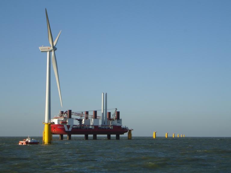
The Humber Gateway offshore wind farm is located 8 km off the East Yorkshire coast, just north of the mouth of the River Humber. The wind farm comprises 73 turbines, has an installed capacity of up to 219MW, and is capable of generating enough electricity to power up to 170,000 UK homes. The total area of the wind farm site is 24.5 km2, located in waters of around 15 m depth.
A key part of the development was the connection of the offshore wind farm into the National Grid onshore, through onshore and offshore cables linked to a new substation. The cable makes landfall just to the south of Easington, from where it largely follows the northern shore of the Humber Estuary, passing through the parishes of Easington with Skeffling, Welwick, Patrington, Ottringham with Sunk Island, Keyingham, Thorngumbald, Paull and Hedon on its route to an electrical substation at Salt End, close to the eastern margin of Kingston upon Hull.
Construction began in 2012 and in 2015 the wind farm became fully operational with all 73 turbines generating two months ahead of schedule. The major elements of the onshore archaeological works (geophysical survey, trenching and excavation) along the cable route were completed pre-construction.


Our Approach
Wessex Archaeology has supported E.ON, and its consultants ERM, on the scheme from 2005 with initial work feeding into Environmental Impact Assessment and Environmental Statements required as part of the consenting process. Three Environmental Statements were required for the offshore works, onshore cable route and onshore substation and cable spur. Planning permission was obtained in 2010 from East Riding of Yorkshire Council (the local planning authority) through Section 57 of the Town and Country Planning Act 1990 for onshore works. Planning permission for the offshore works was obtained in 2011 from the Department for Business, Enterprise and Regulatory Reform through Section 36 of the Electricity Act 1989. Written Schemes of Investigation (WSIs) were produced for both the offshore and onshore works.
Offshore
A baseline review of the offshore development footprint, desk-based and geophysical survey assessment, was carried out by Wessex Archaeology in 2005. The review identified known and potential archaeological resources including: the possible presence of drowned land surfaces and drowned terrestrial sites; known ship and aircraft wrecks and seabed obstructions; documented shipping losses; possible unknown and undocumented wrecks from various periods; possible stray finds of ship-borne debris from various periods; and geophysical anomalies that appeared to be wreck sites or wreck debris. Geophysical survey assessment and review was carried out in 2007 and an environmental impact assessment and draft Written Scheme of Investigation (WSI) prepared. An additional desk-based review was carried out in 2008 covering changes to the proposed cable route alignment. Further geophysical survey assessment followed in 2008, 2011, 2012 and 2013 including review of turbine locations and further amendments to the cable route. A revised Written Scheme of Investigation for mitigation was produced in 2013 and geophysical survey assessment reports updated in 2014.
It has been a pleasure to work with Wessex Archaeology throughout my time on this project, you have been a great team of professionals throughout.
Onshore
A baseline desk-based review of the known and potential archaeology along the onshore cable route was conducted by Wessex Archaeology in 2005. This was followed by walkover surveys of large portions of the route in 2007 along with an archaeological assessment which formed part of an Environmental Statement. In 2008 Wessex Archaeology carried out a walkover survey of a revised section of the route on the outskirts of Salt End. Further archaeological investigations were required by planning conditions attached to for the onshore elements of the project, the cable route and the substation. In April 2011, geophysical survey was carried out of 99 ha along the 30-km onshore cable route, including potential areas for rerouting. A scheme of evaluating the cable corridor, targeting geophysical anomalies and areas which appeared to be devoid of archaeology, was agreed with the Humber Archaeology Partnership (HAP), archaeological advisors to the Local Planning Authority.
Evaluation trial trenching followed in September with 169 trenches (each 30 m long) excavated by three teams starting in different sections of the route. Where significant archaeological remains were identified from the trial trenching, the impact of construction was mitigated through a targeted ‘strip, map and sample’ excavation, carried out concurrent with the continuing trial trenching, and in liaison with the Humber Archaeological Partnership. Nine mitigation areas were excavated through the strip, map and sample approach and all excavations were completed by December 2011, within three months of commencement. An archaeological watching brief was also implemented during topsoil stripping of the whole cable route and substation which identified an additional seven sites.
2217 features of potential archaeological interest offshore
99 ha of terrestrial geophysical survey
10,638 finds weighing over 115 kg recovered
Our Results
Offshore, nine exclusion zones and three buffer zones were established around recorded wrecks thought to include the Nora, Saltoun, SS Marshall, Ionic, and Dido) and geophysical anomalies thought to be of archaeological potential. The zones were agreed with English Heritage and incorporated into the positioning of turbines and cables. A protocol was put in place for monitoring exclusion zones, reporting archaeological finds during construction and for any potential mitigation that might be required. During diving investigations of geophysical anomalies four items of archaeological interest were identified: a possible First World War mine base, an early 19th-century pump-break windlass mechanism, and two anchors thought to be associated with the Nora and SS Marshall. An isolated ‘Hamilton Standard’ type aircraft propeller from a British aircraft was also identified during boulder relocation in a temporary exclusion zone.
Onshore, fieldwork revealed activity from the prehistoric period onwards. Three roundhouse farmsteads of later Iron Age to early Romano-British date were discovered near Easington and Skeffling. A later Romano-British field system was recorded near Hedon and a network of small enclosures dating to the Anglo-Scandinavian period were found near Thorngumbald. The latter site also recorded 12th and 13th century activity, and a further two field system sites, both near Welwick, were also dated to this period. The influence of topography on former settlement patterns was detected in the distribution of sites along the cable route, almost all of which were located on the relatively high ground, above the 5 m contour, at the eastern and western ends of the scheme on slight hills or ridges. Nearly three quarters of the route crossed land lying below the 3 m contour; only the minor site at Humber Side Road was encountered at this level, below which the land was too wet for cultivation and permanent settlement in the past. Publication for the East Riding Archaeologist is nearing completion.