I’m Tyler Froud and this week I have been with Wessex Archaeology for some work experience. I am interested in history, especially the maritime history of the UK. In future my ‘general’ goal is to become a cartographer; especially since 65% of the Earth’s surface is yet to be explored.
Wessex Archaeology makes use of many surveying and sampling techniques to build a greater picture of the past, so I decided to approach them for some experience.
I did have some previous knowledge of archaeological processes; but it turns out that there are some quite complicated things to get your head around and I only scratched the surface.
Geomatics
On Monday I spent the entire day with Roberta who works in the Geomatics department. She took me through using the ‘GNSS Poles’ during the morning. She firstly taught the basics of how it functions. It connects to at least four satellites in the atmosphere in order to triangulate the whereabouts of the pole. This is then corrected by local base stations which help to bring the accuracy to less than a millimetre. She explained how to use it and we eventually set up a practice feature boundary as a red polygon and marked out several pretend features, apart from the carpark drain which was quite real. We exported and sent the files to the office database for later. I then attempted to use the stakeout tool to place the pole onto the exact position of the marker she had set up previously.
In the afternoon she took me through using the two primary pieces of editing software in the huge office (it reminds me of NASA mission control from all the movies), from which the GNSS data is immediately processed. The site drawing was then copied onto AutoCAD where the map can be placed in a perfect template for site reports. She took me through the various tolls and then let me edit some practice site maps.
Environmental
On the Tuesday I joined the Environmental department. There I met Jenny, Sam and the rest of the ‘Enviro team’. Jenny was the person who had to put up with me for the 6 hours I was there.
Firstly, she taught me about the main labeling method they used and how to fill in the paperwork as this was of upmost importance. Each sample bucket consists of a label which contains the site code, specimen number and context number. She then spoke about the ways in which organic material is preserved, mineralization, waterlogging and carbonization (having been burnt).
I did some flotation processing, which meant using two big tanks of water and several filters to separate the ‘flot’ (the primarily organic sediment that floats) and the residue (the bigger sediment that sank). We processed several buckets of this and then moved onto the lab work. She talked through the eight signs of struck flint and we went on to microscope work and separating all the contents, but mainly looking for organic material such as mineralized bone and seeds. I never knew that they had to process samples to such a degree.
Coastal & Marine and Photogrammetry
I was particularly looking forward to this, and on Wednesday I was able to take a look around the Coastal & Marine department and storage unit. In the morning I met Lowri, who took me around and showed me some of the many finds in the warehouse. There were cannon balls, empty artillery shells and even the soles of shoes from a remarkably well-preserved Tudor wreck.
I was next taken to the offices where she explained her role in the company and that of the ‘Marine Aggregate Industry Archaeological Protocol’. As of the Merchant Shipping Act of 1995, all finds from the ocean around the UK must be reported to the correct authorities within 28 days or face fines. It’s very interesting, as most finds originate from the aggregate industry which takes part in dredging on the seabed.
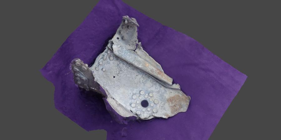
In the afternoon, Beth arrived to take us through the Photogrammetry software we were using: Zephyr and Agisoft. We used each software to 3D model a prehistoric hand axe found in the Channel and a piece of wreckage from an American aircraft. Overall, Agisoft turned out the best model.
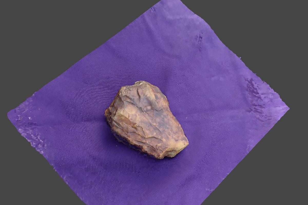
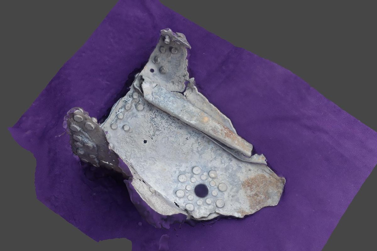
3D models of a prehistoric hand axe, and a piece of wreckage from an American aircraft
Geophysics
On my last day I was directed to the Geophysics department. There I met Dave who talked me through the main types of survey techniques used to survey the ocean floor: Echo Sounding, Side Scan Sonars and Magnetometers. I was also told that companies building giant windfarms, (primarily off the East Coast), undersea cables and other undersea infrastructure use Wessex Archaeology to look for archaeological sites so that they can avoid them, as well as gain an understanding of the ancient geology below the seafloor.
I then spent time around the office with different people who explained their roles in both the Marine Geophysics and Terrestrial Geophysics teams. I made quite a few notes on the various surveying methods and the various maps they use to display all this. I lastly ended up with Richard, who kindly lowered his standing desk for me and explained his role and how to use the GIS software, on which all departments place their data. He explained the main ArcGIS that the office uses and the QGIS which is open source online (I have every intention of tinkering around on it in my free time).
I have had a privilege being able to meet so many people who work at Wessex Archaeology, in a range of different departments. I’m sure what I have learnt here will be valuable to me in the future. I guess all that’s left is to say thank you to all those who gave up time to teach me at least a little of their trades.