 The magnetometer is the standard piece of kit that gets used on most of the sites we look at; we use one made by Bartington (one of the pictures on their website shows Ben in a yellow jacket!). It can cover large areas quickly, and can detect most kinds of archaeology from most periods. It works by sensing tiny differences in the Earth's magnetic field, which is much larger than the tiny signals produced by archaeological features, but the instruments we use are able to ignore this background field and are very good at picking up the relatively weak archaeology.
We can only detect features when there is a difference between the magnetic field occurring naturally and the fields caused by archaeology. Imagine a ditch being dug through the natural soil and rock; the ditch slowly fills up as soil from the site slides in and people throw rubbish into it; and finally the ditch becomes completely full. It is this change in the fill of the ditch from its surroundings that causes a difference in the magnetic field, which we see as an anomaly in the survey data.
This is a very different technique to metal detecting, mainly because we can look for archaeological features such as ditches and pits, but also because the only metal the magnetometer detects is iron. These ferrous objects act just like magnets and have 'north' and 'south' ends; they also tend to produce much stronger anomalies than most other things, and show as spikes from positive to negative over a short distance. Sometimes being able to detect iron can be useful, but mostly the ferrous anomalies we find are just bits of tractors and old steel cans! This also means that our clothes and shoes must be completely free of any zips and press-studs; shopping can be challenge...
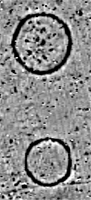
We display the survey data so that negative readings are white, through shades of grey, to positive readings are black; we choose the values so that we get good contrast throughout the survey data. The magnetic background of the site shows as grey because the values lie around the middle of the display range.
The image shows part of a survey we conducted earlier this year. The two circular anomalies are barrows, or burial mounds; the larger one is about 40m wide, and the smaller one 33m wide. After we processed the GPS data we collected as part of the survey, it became clear that the barrows sit on top of a low ridge that was barely visible in the field.
Lots of positive anomalies appear inside the upper barrow and look like pits, but we can't tell from the geophysical survey alone how they are related. The slightly curved line near the bottom of the lower barrow is probably a ditch or old field boundary, but we can't say if it's from the same period. Faint stripes running at a slight angle from top to bottom are the result of ploughing; the field was under a young wheat crop at the time, but may have been ploughed for centuries. There are also some ferrous anomalies sprinkled throughout the data; these stand out because of their characteristic magnetic response.