LiDAR (Light Detection and Ranging) data is produced by attaching a laser-scanner to an aircraft. A cloud of measurement points across the landscape is produced as the laser-beam is fired at the ground and measured when it is reflected back to the aircraft.
Depending on how high the aircraft flies and how the raw data is processed, this typically results in a dataset of points spaced between 25cm and 2m apart, with a vertical tolerance of up to 20cm.
The highly detailed terrain models which can be produced from this data are incredibly useful for identifying archaeological features, even those which can barely be seen with the naked eye. In addition to the spatial component of the data, the intensity of the reflected laser beam is also recorded and this can be used to identify buried features where they cause changes in the vegetation cover or soil moisture content and hence the amount of absorption and reflectance of the laser beam.
Increasingly, this data is being used in our work. Wessex Archaeology has developed an effective methodology for the processing and analysis of such datasets. The biggest problem with these datasets is the volume of data, especially for large study areas. We have overcome this using the latest features in ArcGIS9, using appropriate data storage formats and processing routines capable of handling enormous datasets.
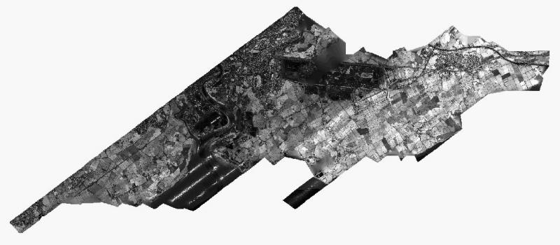
The latest project to make use of this approach to LiDAR data involved the processing of 19 strips of LiDAR data containing 133.5 million data points and covering an area of around 40 square km. This was processed to produce two multi-resolution Triangular Irregular Network (TIN) surfaces suitable for analysis, one for the elevation component and one for the intensity component.
These were used to produce derived analytical products such as hillshaded raster images and slope surfaces at the resolution of the source data (c.1m) ready for interpretation and digitisation of key features.
The advantage of processing this volume of data in one go is twofold. Firstly, any edge effects at the edges of the strips of data are minimised. Secondly, the amount of manual intervention is significantly reduced; had the data been processed in individual strips, it would have been necessary to undertake an additional stage of processing to clip and mosaic the datasets.
Much of this LiDAR data is being produced by the Environment Agency who are surveying areas of the country as part of their Flood Plain mapping programme. There is more information on LiDAR including how to obtain data and coverage maps on the Environment Agency website.
The image below shows an overview of the processed LiDAR data.