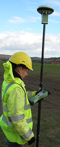
 Wessex Archaeology are pleased to announce the arrival of our brand new fleet of survey instruments from the Leica Viva range of Global Navigation Satellite Systems (GNSS).
These newer GNSS instruments can recieve signals not only from the United States GPS satellite constellation but also the Russian GLONASS constellation, the Chinese COMPASS constellation and soon the European Galileo constellation.
Our new Viva instruments are are all SmartNet enabled. This uses mobile phone networks to provide real-time correction signals from OSNet, the Ordnance Survey's correction signal network. This enables us to begin surveying on most sites within minutes.
We have also upgraded our Total Stations to use the new Viva controllers giving us a single platform for all of our survey instruments; this ensures commonality across the fleet with the same interfaces and data structures in operation irrespective of the instrument used.
The improved interface design and modular nature of the instruments allows us to build on our already highly efficient survey processes, keeping us at the cutting edge of archaeological survey techniques.
Work on the next version of our in-house survey processing software using the latest features available on the Viva instruments is also underway; this will further advance our on-site recording methodology and increase the ease with which we can use survey data in our post-excavation GIS and database based processes.
More information
For more information on our Geomatics services available to clients, see our Geomatics services page or contact Paul Cripps.
For more information on GNSS, see the Inside GNSS website.
For more information on real-time kinematic dGNSS systems in the UK see the OSNet website and Leica Smartnet website.